A line of thunderstorms rolled through Central Minnesota early Friday morning. A severe thunderstorm warning was put in place in Western Wright County from 1:30 a.m. to 2:15 a.m.
Showers and thunderstorms are expected across our area this evening & tonight, and some of those storms could be severe with heavy rain, flash flooding, damaging winds, and large hail possible. Stay tuned to 98.1 FM for any possible watches and warnings.
Last night's severe weather across the area may have just been the opening round for what's expected to be another evening of strong storms. The National Weather Service says storms could become severe late this afternoon and into the night, producing large hail, heavy rain, and damaging winds.
With severe weather possible both today and tomorrow across Central Minnesota, it might be a good time for a refresher on the difference between a Severe Thunderstorm or Tornado 'WATCH,' and a Severe Thunderstorm or Tornado 'WARNING.'
Warmer temperatures return to Central Minnesota this weekend, but with it will come moisture and strong to possibly severe storms both days. The National Weather Service says that most areas of the state will pick up another inch of rain over the weekend.
For more than 20 years, the state of Minnesota has conducted a Severe Weather Awareness Week in partnership with the National Weather Service and local governments. Today's statewide tornado drills are part of that event. 103.7 the Loon along with other radio & TV stations will be participating in the drill.
The National Weather Service says there's a chance of strong to severe storms across Central Minnesota today, with damaging winds, large hail, heavy rain, and isolated tornadoes possible. Stay tuned to 98 Country throughout the day for any watches and warnings.
Forecast models are suggesting that this weekend will not only be another wet one across Central Minnesota; but could also feature severe weather on both Saturday and Sunday. Here's a video discussion from the National Weather Service, and stay tuned to 98 Country this weekend for possible watches & warnings.
Severe thunderstorms are possible across Central Minnesota again late this afternoon into tonight. While the main risk will be strong winds, heavy rain, and hail; an isolated tornado is not out of the realm of possibilities. Any storm development is expected after 3PM in the St. Cloud area.
Showers and thunderstorms will continue to be a part of our weather this week, with more heavy rain and severe weather a possibility through at least Thursday. Southern Minnesota has seen the brunt of the severe weather lately, but the St. Cloud area could get still get a dose this week.
There's a slight risk of severe weather Saturday in the St. Cloud area, with the main threat being large hail, strong winds, heavy rain, and a possible tornado. More showers and storms of the non-severe variety are expected on Sunday. Stay tuned Saturday to 103.7 The Loon for possible watches & warnings.
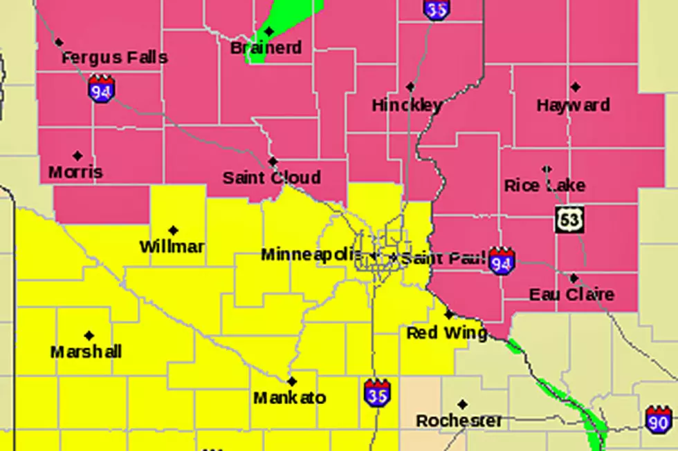
A SEVERE THUNDERSTORM WATCH is in effect until 9pm tonight for parts of Minnesota including and north of Benton, Chisago, Pope, Sherburne, Stearns, Stevens, Swift, and Todd Counties. A TORNADO WATCH is in effect until 9pm south of St. Cloud including Anoka, Hennepin, Kandiyohi, Meeker, and Wright Counties.


![What’s The Difference Between A Watch And A Warning? [Video]](http://townsquare.media/site/66/files/2015/05/Tornado_630x420.jpg?w=980&q=75)