St. Cloud Weather

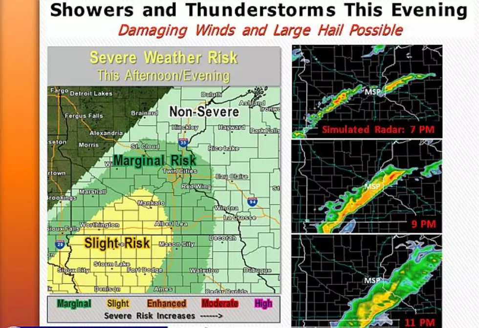
Severe Storms Possible Today
The National Weather Service says a cold front will sweep across Minnesota this afternoon, possibly triggering severe thunderstorms that could produce damaging winds, large hail, frequent lightning, torrential downpours, and localized flooding. Stay tuned to 103.7 The Loon for any watches and warnings.
Severe Storms Possible Across Central Minnesota Sunday
The National Weather Service says a cold front will sweep across Minnesota Sunday afternoon, possibly triggering severe thunderstorms that could produce damaging winds, large hail, frequent lightning, torrential downpours, and localized flooding. Tune to 103.7 The Loon tomorrow for any watches and warnings.
Unsettled Labor Day Weekend Forecast
According to the National Weather Service, it looks like were in for a Labor Day weekend of unsettled weather. No all day rains expected, but a cold front will sweep through the area Sunday and Sunday night -- bringing cooler and less humid conditions early next week.
Tornado Watch In Effect Until 11 PM
The National Weather Service has issued a Tornado Watch in effect until 11 PM tonight for the southern half of Minnesota including St. Cloud, Morris, Willmar, and the Twin Cities. Remember, a Tornado Watch means that storms producing tornadoes are possible in and around the watch area. Tune to 103.7 The Loon for possible warnings.
UPDATED: Severe Weather Possible Today Across Minnesota
Pay attention to the weather today, as strong cold front will sweep across Minnesota this afternoon and tonight -- triggering what the National Weather Service says could be severe storms producing damaging 75+ mph winds, baseball sized hail, and tornadoes. We'll have any watches & warnings on 103.7 The Loon.
Severe Thunderstorms Possible Today & Tonight
Showers and thunderstorms will be on the increase as we go through the day today and into this evening. A few of the storms could be strong to severe this afternoon and evening   -- with locally heavy rain, large hail, and damaging winds possible.
UPDATED: Severe Weather Possible Tonight & Tomorrow
Thunderstorm chances will increase from the west tonight. Some of the storm may be severe with large hail and damaging winds tonight and tomorrow. Torrential downpours will occur with the stronger storms. Stay tuned to The Loon for possible severe weather watches & warnings.
Severe Weather Possible Tonight Across Central Minnesota
Showers and thunderstorms are expected across our area this evening & tonight, and some of those storms could be severe with heavy rain, flash flooding, damaging winds, and large hail possible. Stay tuned to 98.1 FM for any possible watches and warnings.
Cold, Wet Week Ahead For Central Minnesota
Rain, sleet, snow, and ice are all on the menu for Central Minnesota this week, with below average highs adding insult to injury. A Winter Weather Advisory is in effect for areas north of St. Cloud through 10 AM Monday morning for up to 3" of snow. Included in the advisory are Brainerd, Little Falls, Princeton, Cambridge, Mora, and Hinckley.
Spring Returns To Minnesota This Week
Spring will return to Minnesota this week after a stretch of cooler than normal weather. Yesterday's wind and rain will give way to sunshine and temps in the 60s & 70s through Wednesday -- then things cool back down again at the end of the week, with our first chance of Spring thunderstorms coming on Wednesday.

Load More Articles